

The Lochcarron district has a wealth of walking opportunities for all tastes and abilities. There are charming woodland and riverside strolls, old hill paths, forest trails and demanding hill-walks to our local summits. The selection in this guide covers this full range. Written by Martin Moran.

© Michael Stuart Green
Many shorter routes are community Core Paths designated and maintained by the local Council. These routes are usually marked and signposted. Other walks use old Rights of Way that provided vital links between communities before the advent of car travel. The upland routes often follow stalking paths, built in the 19th century to provide access for deer shooting and retrieval by horse. Some sections are rough and pathless. Nearly all routes described are circular to facilitate car users. More experienced hill-walkers can go beyond the bounds of these walks to enjoy the magnificent mountains of the area. We have nine Munros (peaks over 3,000 feet high) and eight Corbetts (hills over 2,500 feet high) within a 10 mile radius of Lochcarron. Before using this guide please carefully read the User Information. Accept responsibility for your own safety and remember the Scottish Outdoor Access Code. Enjoy your walking!
The above button is a link to the GetOutside website’s Lochcarron page
User Information
GRADES OF WALK Four levels of walk are described in the text and maps.
GRADE 1 GREEN Easy strolls on good trails and roads with low gradients.
GRADE 2 BLUE Low level walks on good paths with some steeper sections.
GRADE 3 RED Rough walks, sometimes pathless, with steep or wet sections.
GRADE 4 BLACK Hill routes above 300m altitude, exposed to the weather and often pathless.
Many Grade I and Grade 2 walks are signed and waymarked. The walk maps use colour codings for each section.
ACCESSIBILITY Walks or sections of walks suitable for Wheelchair access are denoted (W) in the text and routes suitable for off-road biking are denoted (B).
DISTANCES AND TIMES
Distance (Km), amount of climbing (in metres) and estimated times are given for each walk. The times assume a walking speed of 3 to 4 km/hr according to terrain, with addition of 10 minutes for each 100m of ascent, and provision for rest stops.
EQUIPMENT AND PRECAUTIONS Walkers must take clothing and footwear appropriate to the level of walk plus drink and snacks. On all Grade 3 and Grade 4 routes boots with ankle protection are recommended plus a map and compass (and the ability to use them!). Ordnance Survey 1:25000 Explorer sheets nos. 428 and 429 and 1:50000 Landranger sheets nos. 24 and 25 cover the area of this guide.
BE AWARE OF SEVERAL SPECIFIC HAZARDS
attempting to cross swollen streams after heavy rain can be highly dangerous
grazing cattle should not be disturbed, especially cows with young calves
many paths become slippery and treacherous after wet weather
SCOTTISH OUTDOOR ACCESS CODE Public access to the land is defined in law by the 2003 Land Reform (Scotland) Act on condition of “responsible behaviour” as specified in the Access Code:-
act with courtesy and consideration to the privacy and peace of others
do not hinder those who earn a living from the land
care for wildlife, historic and cultural features
accept responsibility for one’s own actions and safety
SOME SPECIFIC GUIDELINES
1) Keep dogs on lead in all sheep and cattle grazing areas
2) Park cars responsibly without blocking access
3) Do not start fires (or drop lit matches or cigarettes)
4) Do not leave litter and close all gates that you open
5) Restrict cycling to surfaced trails and roads; protect fragile upland paths
6) Beware of forest operations (obey signs and stay clear of machinery)
7) During the deer stalking season (mid-Aug to mid-Oct) contact local estates to check on access to avoid disturbance of deer (low-level routes are not affected).
You will also find details of these and other local walks on the walkhighlands.com website
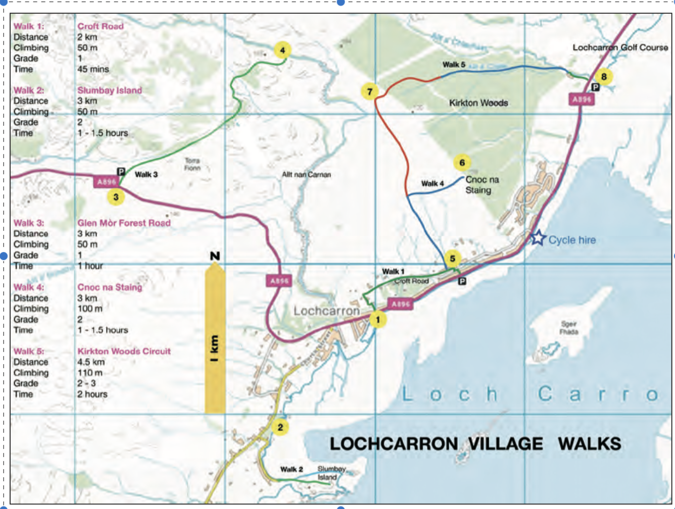
Lochcarron Village Walks
Lochcarron village offers several shorter walks. Dogs should be on lead at all times.
1. CROFT ROAD CIRCUIT There are three signed paths up steep cuts between Main Street and Croft Road. Start up the link near the Church of Scotland (1), enjoy scenic views from Croft Road and take one of the paths back down to Main St. 2. SLUMBAY ISLAND Park at the W end of Main Street and turn left on the road to North Strome. After 1km turn left down to the anchorage and rock knoll of Slumbay (2). Follow the access road climb to the summit of the “island” which offers fine views.
3. GLEN MÒR FOREST ROAD Start at the summit of Kishorn Hill on the A896 11⁄2km above Lochcarron (3). Park at the electricity sub-station and follow the forest road for 1km and up to a junction. Turn right and walk to the road end at the Allt nan Carnan (4) (B).
4. CNOC NA STAING The best viewpoint in
Lochcarron. Start from Main Street at Pathend (20m W of Rockvilla Hotel) (5). Take the steep path and cross Croft Road, continuing past the Wee Camp Site and up the track through gorse thickets to Kirkton Moor. At the top of the hill turn sharp right and follow the path for 150m to the knoll of Cnoc na Staing (6). The vista of Loch Carron and hills makes a perfect panoramic photo.
5. KIRKTON WOODS CIRCUIT This longer walk requires boots. Park at the Golf Course or on Main Street (5). Follow route 4. to Kirkton Moor. A detour to Cnoc na Staing is recommended. Then head NW across the moor on a firm path with boggy hollows, bearing right at a junction. The Allt nan Carnan is on the left. After 3⁄4km a gate is seen to the right on the fence of Kirkton Wood. Turn right (cairn) (7), cross the gate and follow a path down a break through the forest - marshy at first then improving. At the bottom of the woods cross a gate, ford the Allt na Clachain and pass above a cottage to a stand of beech trees at the top of the Golf Course. Keeping dogs on lead and taking care not to disturb any play, go down the vehicle track down the right side of the course to the main road and car park (8).
Carron River Walks
Strathcarron offers easy riverside walks. Park at the Smithy Heritage Centre by Ribhuachan on the A896 2km NE of Lochcarron village (1), or a picnic area 1km W of Coulags on the A890 (7). Dogs must be kept on lead across all fields and grazings. At the Heritage Centre the Treehouse Trail offers a 5min circular walk through the woods past the riverside tree-house (W).
1. NEW KELSO CIRCUIT From the Heritage Centre (1) cross the A896 and take the path signposted to New Kelso and Strathcarron. The track goes through two gates to open estuary flats and crosses a ford over the Balnaglash Burn. Continue for 1km, passing a field gate to meet the A890 (2). Turn right, walk 70m to the Carron Bridge and go through a gate on the left (sign to Coulags) (3). The riverside path runs round a wide curve in the River Carron (waymarks) to a gate just E of the old New Kelso house (4). Either: i) Leave the riverside and go left across open parkland to meet the access drive for the New Lodge. Follow this back to the A890 at (2) and retrace the first section of the walk; or ii) Continue on the left side of the riverside fence for 300m past New Kelso Lodge. Turn left away from the river 50m before a red-roofed bothy. A track goes right of New Lodge (waymarks) to a forest gate. Continue along the forest track to meet the A890 1⁄2km E of Strathcarron Junction (5). Turn left and walk 1km back along the road to the Heritage Centre. (B)
2. RIVERSIDE PATH TO COULAGS A popular trail for dog-walking and river fishing. The route can be started at either end. From the Heritage Centre follow the New Kelso Circuit to (4) and continue along the riverside fence past the bothy to a gate at a plantation. From here follow a 4x4 track, crossing a burn by a metal bridge, and passing an old gravel pit. Go through another gate into thicker woods and on to a ford (6). From here a worthwhile detour right can be made to the river bank. Continue for another 1⁄2km to the A890 near Coulags (7). Arrange collection here, retrace the walk or walk 21⁄2km back along the main road to the Heritage Centre. (B)
Achintee & The Two Lochs
This fine walk explores the moors south of Strathcarron, a land of hidden lochans and craggy gorges. Boots are essential as there is one section on marshy moor without a clear path.
From the car park at Strathcarron Station (1), walk W on the A890 for 200m to the road to Achintee. Turn sharp left at the top of the access hill, then swing right on to a rough vehicle track and pass an electricity sub-station (signs) (2).
Cross a gate, go up the hill to the top of the track (signpost to Bendronaig Lodge) and bear right on to an upland stalking path, which climbs through young woodland. Don’t miss a sharp left turn at a rocky outcrop (cairn) and continue to a deer fence and stile. The path crosses open moor and ascends a shallow valley. At its top Loch an Fheòir comes into view. Turn left (cairn) (3) and traverse round knolls on to level moor at 280m altitude. A second loch, Loch nan Creadha, is now ahead. Both lochs offer trout fishing. Head NE for 1km, keeping the burn linking the lochs on the R. At Loch nan Creadha turn left down the outlet stream and after 100m pick up an old path (cairn) (4). Descend the path NW steeply downhill alongside a little gorge to meet the Berneas hill track on the lower moor (5). Turn left and follow the path back to Achintee, crossing the Allt an t- Sagairt and stile. A path through the woodland leads back to the gate at the sub-station (2). If time and weather allow it is highly recommended to detour to the Taodail gorge from the knoll before the final descent to Achintee. Go 1⁄2km down the edge of the gorge (6) to view the impressive 45m ravine clad in Scots Pine and oak with triple-tiered waterfall, Eas an Teampuill (temple fall). A temple may have existed here in the early days of Christianity. The gorge has been cut as land has risen from the removal of the 1000 metre covering of ice during the Ice Age. The brink of the gorge gives fine vantage but beware. This is not a place for frisky dogs or young children.
Stromemeanach & Bad a’Chreamha
West of Lochcarron village a minor road runs along the north side of the loch to North Strome, Strome Castle and Ardaneaskan, passing through attractive crofts and woodlands. The ruined
Strome Castle stands on an isthmus of hard rock at the narrows of the loch and commands a fine vista west to the hills of Skye. Between the west end of the village crofts and the castle there are two walks to enjoy, one an easy stroll to the abandoned township of Stromemeanach and an extension climbing to the 395m summit of Bad a’Chreamha (copse of the wild garlic), a magnificent viewpoint. Parking for both walks is found at the cattle grid just beyond the 30mph signs 2km W of the village where the road enters Strome Carronach plantation (1). Dogs must be kept on lead on the sheep grazings of these walks.
1. STROMEMEANACH Walk 1km W along the road to the bridge and Lochcarron Weavers Shop (2). After 50m turn right (sign and barrier) and follow a firm path up through Strome Wood and across open grazings to the ruins of Stromemeanach settlement (3). The walls of the ’black houses’ and a circular kiln by the stream are well-preserved. The township was abandoned in the late 19thC and most of the residents emigrated to America. There is a fine view of upper Loch Carron. Retrace the walk back to the car.
2. BAD A’CHREAMHA For those with sturdy boots who don’t mind rough terrain the climb from Stromemeanach to Bad a’Chreamha is very worthwhile. Continue past the settlement for 250m and cross a small stream. Follow the hummocky ridge up the left side of the stream, climbing NW through bracken and tough heather for 30 minutes to gain the summit ridge (4). Perseverance is well repaid by the breath-taking view which encompasses Applecross, Glen Carron, Plockton and the hills of Skye. Return by the route of ascent.
Reraig Forest & Achintraid
The peninsula between Lochs Carron and Kishorn is a beautiful area for exploration with fine views over the sea to the Cuillin Ridge of Skye and Applecross hills. Walks commence on both south and north sides of the peninsula, which can be reached in short drives from Lochcarron village. In croft grazing areas dogs must be kept on lead and walkers should beware of disturbing cattle, especially when cows and calves are together. Ardaneaskan and Reraig Forest.
Two circular walks can be made from the settlements of Leacanasigh and Ardaneaskan, 8km W of Lochcarron village, which are reached along the minor road to Strome Castle. Turn right at North Strome. The road twists over to the lovely shingle bay of Port a’Mheirlich (Smuggler’s Cove), and climbs into forest plantations for the final mile to Ardaneaskan road-end. Here, a small car park offers a fabulous view over the sea to Plockton and Skye. With the addition of a walk this makes a delightful half-day excursion.
1. RERAIG FOREST LOOP This is an easy stroll, which starts at the Ardaneaskan car park (1). Take the unmetalled road that goes N to Reraig bay (bridge) (2) (W). Continue along the road past Reraig Cottage, enter the forest and make a circuit of the Reraig valley. When the road ends take a path by the fence to a gate, which leads back to open grazings at the bridge (2), then retrace the road back to Ardaneaskan (B).
2. LEACANASIGH AND RERAIG This is a longer circuit and the initial path is steep and slippery after rain. Start at the small car park at Leacanasigh (2km before Ardaneaskan) (3) and climb a steep rocky path to a forest road. Go 00m along the road, then turn right along the continuing path, which crosses a ridge with fine views before descending to meet the Reraig Forest road (sign) (4). Turn left or right here and follow the Reraig Loop walk to Ardaneaskan (1). Now take the public road through tall pinewoods back to Leacanasigh.
ACHINTRAID AND KISHORN ISLANDS The beautiful bay of Achintraid is reached by taking the A896 from Lochcarron to Kishorn (6km). Turn left and drive through Ardarroch to parking lay-bys at the entrance to Achintraid township (5). Please don’t take cars into the village as space is limited. Achintraid offers an easy forest walk to Kishorn Islands, a through-route to Reraig on a good path, and a rough circuit of the moorland grazings.
3. KISHORN ISLANDS Walk along the road through Achintraid and birch woodlands to a gate at the forest entrance. The forest road continues SW for 21⁄2km, passing the ruins of old townships and giving fine views over Loch Kishorn. Bear right at a fork in the road and descend to the road- end, which is directly opposite Kishorn Islands (6). There is a fine viewpoint just beyond the trees. A rough narrow track leads down to the shore, where shingle beaches can be explored and a picnic enjoyed. There are seal colonies on the islands and the shoreline is home to otters. Retrace the route back to Achintraid (W) (B).
4. ACHINTRAID-RERAIG HILL PATH The old “right of way” between Achintraid and Reraig has recently been improved to provide a fine walking path. The route links with the Reraig walks but must be reversed unless collection can be arranged at Ardaneaskan or Leacanasigh. From the parking places at Achintraid (5) walk into the township and turn left after 100m (sign). A vehicle track leads uphill. Bear left at a fork, continue through a gate and alongside a cleared forest planting, The path then turns up right to gain the ridge of Blàr nan Clachan Mòra (clearing of the big stones) (7). Photographers should be here early in the day for the magnificent view over Loch Kishorn to the Applecross mountains. The path now descends gently for 1km to the entrance of Reraig forest (gate) and continues to meet the Reraig loop road (8). The walk can be extended to Leacanasigh or Ardaneaskan by Walks 1 or 2, and a return to Achintraid made by the same path (B).
5. ACHINTRAID MOORLAND CIRCUIT Adventurous walkers with boots can make a rough circuit of the common grazings from Achintraid; recommended only in dry clear weather. Follow the hill path of Walk 4 to the point where it crosses the burn before the entrance to Reraig forest. Follow the right bank of the burn for 1⁄2km to reach the forest perimeter fence at a stand of birch trees. Turn right and follow a boggy trod W alongside the fence. There are two options for completing a circuit of the moor:- i) turn right where the path reaches the top of the moor before the fence drops towards Lochan Dubha (cairn) (9). A cairned path heads N across the moor for 1km, keeping to rocky slabs and knolls, and drops diagonally right to the wall at the upper edge of the croft fields. Bear left along the wall to a gate at a stock fence and follow a tractor track to meet the road; or ii) follow the forest perimeter fence past Lochan Dubha, making a detour to avoid a shallow boggy loch, and continue on the outside of the fence, descending N on boggy trods through birchwood to meet the Achintraid road at the forest entrance.
Attadale & Loch An Iasaich
On the south side of Loch Carron, the green strath of Attadale is an oasis of pastoral beauty with a fine estate house, woodland, walled fields and gardens, all set against a backcloth of wild hills. Visitors can enjoy a short stroll combined with a visit to Attadale Gardens, or make a longer walk around the forest tracks to the south. For all walks from Attadale there is a designated parking area by the A890 just inside the entrance drive to Attadale House (1).
ATTADALE STRATH AND GARDENS From the car park follow the metalled estate road round to a T-junction and turn right. The road leads for 1km to Strathan cottages (gate) (W). A rough road continues for another kilometre to a bridge over the River Attadale (2). Retrace the route back to the junction near Attadale House. Either turn left back to the car park or continue to visit the Gardens, which are open from April to October.
LOCH AN IASAICH CIRCUIT Follow the road to the bridge over the River Attadale (2) and continue up the vehicle track, which winds up the braes to the south just left of the forest edge. Go past a forest entrance (3) and continue for 500m to a second entrance just before a small burn (4). Turn right here (sign) and follow a good track through the forest for 1⁄2km to a junction (5). Turn right again and ascend the forest road, ignoring cul-de- sacs to left and right, until Loch an Iasaich comes into view. The loch shore (6) provides a nice picnic spot. The forest road now bends round to the N. Turn left at a junction after 100m. The track makes an undulating loop round the forest for 2km. Keep right at any further junctions. There are fine views over Loch Carron, Applecross and the Killilan hills. Rejoin the approach road at the first junction (3). Turn left and retrace the approach back to Attadale. This is an excellent circuit for mountain bikes (B).
Stromeferry & Achmore
Loch Carron is a “fjord” carved by massive glaciers during the Ice Ages with a narrow entrance at Strome. A ferry service operated across the narrows prior to the opening of the A890 by-pass road along the south shore of the loch in 1971. The by-pass road has proved a mixed blessing, having suffered several closures due to rockfalls. The communities on the south side of Strome narrows, Stromeferry and the nearby village of Achmore, offer several walking opportunities with spectacular views across lower Loch Carron to Plockton, Skye and Applecross.
STROME WOOD FOREST WALKS A network of short forest walks has been created by Forest Enterprise in partnership with the local Fernaig Community Trust in the steep forest above Stromeferry. The views are dramatic and exquisite. Turn off the A890 at the sign for Stromeferry and park on the left at the forest entrance after 200m where the road bends right (explanatory signboard with map) (1). The main track leads through the forest for 3⁄4km to a viewpoint for the narrows of Loch Carron (2). There are maintained trails on the uphill side of the main track, which lead to further viewpoints and offer a pleasant circuit of 45min. There are also routes below the main access track, but these are steeper and can be slippery.
1. FERNAIG SHORE AND CREAG MHAOL This is a short circular walk which offers the option of a steep ascent to the viewpoint of Creag Mhaol. Walkers of all abilities can enjoy the first part of the walk to Portchullin (W). Dogs should be kept on lead throughout this walk, which is on croft land and common grazings. Turn off the A890 to Achmore village, and turn on to the side road, signed to Fernaig, in the village centre (parking available opposite the forestry workshop after 50m) (3). Walk down the metalled road for 1km and go under the railway bridge to reach Fernaig shore. The road runs along the shore for 1⁄2km to Portchullin. Turn right on a track under the railway, which ascends to a remarkable plateau of rough heather (4).This is a raised beach, left high and dry by post-glacial rise in the landmass. Follow a vague path close under the steep slopes of Creag Mhaol (waymarks) until directly below a steep hollow which drops from the saddle between the two summits of the hill. Energetic walkers should climb to the saddle and gain the left-hand summit, which gives a splendid seaward panorama. Descend back to the traverse path, turn left and continue to a gate at a ruin (5). Cross two gates and follow the right edge of a field down to rejoin the Fernaig road. Turn left back into Achmore village.
2. ACHMORE GLEN CIRCUIT This is a long but simple circuit on good forest roads, well suited to off-road bikes (B). Approaching from Lochcarron, park at a layby on the right side of the A890, just after the road bends into the valley, 400m after the junction for Achmore village (6). Take the forest road opposite, which climbs diagonally uphill, passing a disused quarry. The forest road makes an undulating circuit of Strath Ascaig at 150m altitude, giving some fine views. The road loops tightly round a side-valley, then cuts south through the gap of the Bealach a’Choire to Gleann Udalain. Turn right at a T-junction (7) and walk 3km along the level road to the A890 (8). Turn right and walk along the main road for 1km, then take a left turn and follow the minor road down to Braeintra (9). At the entrance to the hamlet turn right and follow a gravel road back to the A890. Wide grass verges offer safe walking back to the parking lay- by. Cyclists will find this route more enjoyable if followed in the reverse direction.
Loch Gaineamhach & The Beinn Bhan Corries
These walks use a good stalking path to visit Loch Gaineamhach (sandy loch) and sample the dramatic scenery of 896m Benn Bhàn, highest of the Applecross hills. The route to Lochan Coire na Poite is rough but reveals some of Scotland’s grandest mountain scenery. During the Aug 15th to Oct 20th stalking season call the stalker (01520) 744247 to check on access.
1. LOCH GAINEAMHACH Start from parking lay- bys on the left of the Bealach na Ba road just before Drochaid Mhòr at Tornapress 9km W of Lochcarron (1). Cross the bridge, turn right and follow a good path which runs N above the Kishorn River for 2km then curves NW on to the lower slopes of Beinn Bhàn. Cross a footbridge, then a ford over Allt Coire na Poite (2), and follow the path for a further 11⁄2km to Loch Gaineamhach, a narrow and shallow loch at 285m altitude (3).
2. LOCHAN COIRE NA POITE The extension to Lochan Coire na Poite leaves the stalking path just past the ford at Allt Coire na Poite (2) and ascends WNW for 11⁄2km alongside the burn to a sudden and dramatic revelation of the corries of Beinn Bhàn just before the lochan (4). Lochan Coire na Poite (370m) has sandy shores fringed by sandstone slabs to make a perfect lunch-spot. The three central corries Coire na Feòla (flesh corrie), Coire na Poite (corrie of the pot), and Coire an Fhamair (giant’s corrie) together form the country’s greatest assemblage of glacial corries and are famous for winter climbing. For both walks retrace the routes back to Tornapress.
Applecross Village Walks
The path network around Applecross Village offers pleasant short walks. There are two start points - the village car park on the shore, and a gravel parking area by the Walled Garden in Applecross House grounds. A circular walk is described from each plus a longer linked circuit. Keep dogs on lead on all areas of farm and croft land.
1. MILLTOWN LOCH AND THE ARCHAEOLOGICAL TRAIL From the village car park (1) walk S along the Toscaig road to Milltown township and continue to the south end of Milltown Loch (2). Turn left on a road round the E side of the loch and turn right just before a cottage (waymark). Follow the path uphill to join a rough road at another cottage. After 50m turn right into Torgrave Wood (sign for Archaeological Trail) (3). The signed trail weaves through a plantation, passing an old enclosure with a ruined corn-kiln, then makes a twist right up the Allt Breugach at the edge of the wood. A path runs N along the top of fields passing a viewpoint. Turn left at a junction (4). Descend the Smiddy path, and down the road to the village shore.
2. WALLED GARDEN AND ROES’ WALK Drive 1km N of the village and up the metalled access road to the Walled Garden car park (5). Take the path on the right which climbs through woodland to meet a gravel road. Turn left and follow the road round past the Ice Pond. After passing a cottage turn right on to the Roes’ Walk (sign) (6). This makes a 1km loop round the northern edge of the estate grounds to meet the River Crossan at Home Bridge (7). Turn left here and take the metalled road past the House back to the Walled Garden.
3. VILLAGE AND ESTATE CIRCUIT Follow Walk 1. to the junction (4). Continue straight on and cross the motor road. Continue on a landrover road, passing Keppoch and descending into woodland. Follow the road to junction (6) and follow Walk 2 round the loop and back to the Walled Garden (5). Walk down the entrance drive and take a path on the left where it meets the public road. This traverses above the road back to the village and car park.
Bealach na Ba Tops
The 626m (2,053ft) Bealach na Ba (pass of the cattle) is Britain’s second highest public road pass. In clear weather it us arguably the country’s finest scenic drive. The road was built between 1818 and 1822 and much of the original stonework still survives. Until the north coast road was opened in 1976 the pass provided the only road access to Applecross. The adjoining summits offer short ascents and great views. The land-rover track to the masts on Sgurr a’Chaorachain is a simple climb, but the terrain beyond is rough and exposed in places. Wear boots and take warm weatherproof clothing. The routes described are not usually affected by deer stalking.
1. MEALL GORM This is the summit to the S of the pass at the top of the cliffs above the hairpins. From the summit car park (1) walk SE back down the road for 1⁄2km to the top of the hairpins. Branch off right and cross the plateau S to a steep scarp. Clamber up the boulder-covered slope (traces of path) and gain the summit plateau. Continue S to the crowning cairn at 710m (2) and enjoy a superb panorama across the Inner Sound to Skye. In clear weather the cliff edge offers tremendous views down to the road 300m below. Retrace the route back to the pass.
2. SGURR A’CHAORACHAIN From the car park (1) walk 50m SE back down the road, turn left and follow the land-rover track for 11⁄2km to the masts on the north summit of the mountain (3) (B). Most walkers return from here but the higher south summit lies 2km to the SE along an undulating ridge and offers the finest panorama. There is a small path and the final craggy lump on the ridge is by-passed on the left (N) side. The summit cairn (792m) (4) gives an unchallenged view over Loch Kishorn to the mainland ranges. The safest return goes back up to the mast but in clear weather this can be by-passed on the W side to join the land-rover track half-way back to the road.
Coulags & Maol Chean-Dearg
An important Right of Way starts at Coulags, 6km NE of Lochcarron on the A890. The path follows the Fionn-abhainn up Coire Fionnaraich and over the Bealach na Lice to Torridon. A popular short walk can be enjoyed as far as the Coire Fionnaraich bothy 3km up the valley. This can be extended into a full-day circuit of the Munro-peak of Maol Chean-dearg (933m). Dogs must be kept strictly on lead on the walk up to the bothy where sheep are grazed. Walk 2. should be avoided during the deer stalking season in Sept and Oct.
1. COIRE FIONNARAICH BOTHY Park at the lay- by just W of Coulags Bridge (1). Take the signed path starting at the gate just E of the bridge. This passes below Coulags Lodge then ascends gradually up the open glen for 2km and crosses a bridge over the Fionn-abhainn. The bothy lies a further 1km up the track and offers welcome shelter for a rest and a snack on a wild day (2). Return by the same route.
2. RING OF MAOL CHEAN-DEARG This is a long and exhilarating hill-walk. Follow Walk 1. to the bothy and continue for 1km to a path junction (3). Turn left and ascend the stalking path for 2km to the Bealach a’Choire Ghairbh (587m) (4). The Munro summit of Maol Chean-dearg can be climbed from here up a broad rocky ridge (allow 11⁄2hr for the return trip). The summit view of the Torridon peaks is dramatic. The ring-walk descends 100m down the west side of the pass to pick up another stalking path, which skirts Loch Coire an Ruadh-staic and runs NW then N for 3km to the outlet of Loch an Eoin. Here the main Coulags-Torridon path is met (5). Turn right and follow the path SE over the Bealach na Lice and down Coire Fionnaraich, passing its’ lochan, to complete the circuit. Continue past the bothy and back to Coulags.
Achnashellach Roads Circuit
Achnashellach Forest was planted by the Forestry Commission in the 1920’s and the second generation of trees is now growing. With pockets of native and broadleaved trees the forest is an attractive place for naturalists and walkers.
This walk follows good forest roads on the N side of Glen Carron with one short section of steep narrow path. Start on the A890 12km NE of
Lochcarron, at the gravel parking lay-by opposite the entrance to Achnashellach station (telephone box) (1). Alternatively, the walk can be commenced from a lay-by 1km further E and 300m E of the railway bridge, joining the route at point (6). There may be timber operations encountered on walks in the forest - take care and obey signs.
Walk up the access road to the station, cross the railway at the white gates and continue to a forest crossroads (2). Go straight ahead (signpost to Coulin Pass). The road makes a gradual ascent diagonally up the hillside for 21⁄2km, passing several pretty cascades and affording fine views in cleared sections. Keep left at a fork and continue to a gate at the Coulin Pass (287m) at the top of the forest. After a further 200m a beautiful panorama unfolds over the hills of Slioch, Beinn Eighe and Beinn Liath Mhòr (3).
Retrace the route back down the forest road and after 400m a path drops down to the left
(Pony Track, sign) (4). This zig-zags steeply downhill, dropping 80m to a waymark and junction (5). Turn right here and traverse 100m to the end of a forest road which leads down to the valley bottom just above the A890 (6). Turn right and follow the level forest road which runs just above the railway for 11⁄2km back to the crossroads (2). Turn left and go back down past the station to the road.
The Coulin Pass is a rewarding route for cyclists, and the horizontal section between points (2) and (6) can be enjoyed by wheelchair users (W).
The Coulin Circuit
North of Glen Carron the Coulin deer forest contains the first bold thrusts of the Torridonian mountain chain. Alternating layers of sandstone and quartzite, often tilted at crazy angles, make uniquely impressive mountain scenery. Between the mountains a network of stalking paths offers linked walks through lonely corries and pine-clad glens. This circuit is one of the best and most popular and follows good tracks throughout. During the stalking season from 15th Aug to 20th Oct keep to the route described, and if going further into the hills call the stalkers (01520) 722703 and (01445) 760383 to check access. Start from the car park opposite the access road to Achnashellach station 12km NE of Lochcarron on the A890 (1). Go up to the station, cross the railway and turn left at the forest crossroads. Follow the level track for 700m, enjoying fine views ahead to the craggy peak of Fuar Tholl (907m) (the cold hole). At a cairn/waymark (2) turn left and go 50m down to join the old stalking path on the bank of the River Lair. Follow this track out of the forest, passing ancient Scots Pines. At two points you can detour to view the chasm and waterfalls of the river. The path winds through rocky slabs into the glaciated valley of Coire Lair. Keep right at a path junction and continue to a second junction 100m beyond (3). The main route goes right here, but if time allows it is recommended to detour 11⁄2km further into Coire Lair to see its fine lochan and view the cliffs of Sgorr Ruadh (942m).
Returning to the junction take the path NE through heather and boulder-fields. The path descends the valley of Easan Dorcha for 21⁄2km to a small bothy, then continues on a vehicle track past pinewoods to a junction at a stone-arched bridge (4). Turn right here and follow the land-rover track 3km S to the Coulin Pass (287m) (5), which offers a fine retrospective view of the Torridon hills. The track re-enters Achnashellach Forest and descends diagonally for 21⁄2km back to Achnashellach Station and the main road.
Allt a’Chonais Woods & The Golden Valley
The south side of Achnashellach Forest has several pockets of native Scots Pine wood which can be explored from a forest car park at Craig, 3km E of Achnashellach on the A890.
1. ALLT A’CHONAIS WOODS This beautiful wood is easily reached on forest roads. The continuation round the Allt a’Chonais gorge is a good circuit, but is rough and requires boots. From Craig (1) cross the railway, follow the road for 1⁄2km and over a bridge over the River Carron (beware cattle). Bear left and climb the forest road for 1km. Turn right at the second of two junctions (signpost) (2) (B). After 200m leave the track (sign) and zig-zag steeply down to a bridge over the Allt a’Chonais (3). Scramble up into the pinewood which is carpeted with thick heather, bilberry and moss. The walk can be reversed from here. To continue on the circuit go SW through the pines and cross a side-valley. The way is cleared and marked, and follows the woods on the edge of the gorge of Sloc Mòr for 3⁄4km, giving a fine view of the main waterfall (4). The woods end at a gnarled pine. Bear left over open heather with a mix of young trees and old pines. Descend the left edge of the gorge (cairns, markers). After 1⁄2km of heather the bottom forest road is reached (5). Turn right and rejoin the approach at the Carron bridge.
2.GOLDEN VALLEY AND CREAG AN EILEIN An attractive native wood and fine viewpoint can be combined on this walk. Bikes will speed the approach along forest roads (B). From Craig (1) follow the Allt a’Chonais walk over the bridge then bear right and take the road along the valley floor for 3km past Allt Leth-allt (6). The road turns uphill. After 400m take a path left (sign) (7), which drops down to the Golden Valley. Ford the stream and enjoy a wander among stands of Scots Pine, birch and larch, before returning to the forest road. For Creag an Eilein turn left to the end of the road and take the onward path leaving the woods at a gate. Go diagonally up the hill. After 300m turn back up right on a prominent deer path to the top edge of the forest (fence), then back left to the summit of Creag an Eilein (291m) (8), which gives a fine panorama of the Achnashellach hills. This ridge should be avoided in the Sept 15th-Oct 20th stalking season. Retrace the walk to Craig.
Sgurr na Feartaig
Although not a Munro, 862m Sgurr na Feartaig gives one of the best hill-walks in the district, not least because there is a stalking path across the summit ridge. The name means hill of the sea- pink (thrift). This hardy plant, which produces a sea of pink blooms on the River Carron estuary each June, also thrives on many hill-tops. This is a high and lengthy walk, requiring boots, warm clothing, map and compass. The route should generally be avoided during the Sept and Oct stalking season, but the stalker can be contacted on 01520 722703 for day-to-day access information.
Start at the Craig forest car-park on the A890 15km NE of Lochcarron (1). Go across the railway at the gates and follow the road to a bridge over the River Carron. Turn left 50m beyond at a junction (2), and follow the forest road ESE, keeping left, for 2km. Leave the forest at a gate and continue on the vehicle track into the open upper valley of the Allt a’Chonais. After 1km turn right on a faint track to a wire footbridge over the river (3). Cross this with care, turn sharp right and after 100m look carefully to find the start of a stalking path. The path zig-zags SW for 3km up to the summit of Sgurr na Feartaig, crossing a
subsidiary top of 819m and then a saddle with a lochan before passing 200m N of the highest point (4). Make a detour to the summit cairn, which is vantage for over fifty Munros including the Torridon, Cannich and Monar ranges.
Regain the path and follow it WSW for 2km along a pleasantly narrow ridge and over a subsidiary top (805m) before it drops to a junction on an open plateau (5). Turn right to a downfall, which the path negotiates by a series of neat turns, before dropping NNW down Coire Leiridh to reach Achnashellach Forest at a gate. Descend to the forest road on the valley floor (6), turn right and follow the forest road for 3km back to the bridge over the River Carron and thence to Craig.